

Latest Headlines
- Camp Fire Century, The Town’s Only Childcare Facility, Closes Permanently On Friday
- Operation Southern Slow Down Begins: Five States Launch Coordinated Speeding Crackdown
- Atmore Community Hospital Files for Chapter 11 Bankruptcy, Vows to Keep Doors Open
- Century Awarded AARP Grant For Pedestrian Safety And Walkability Study
- Federal Court Halts Florida ‘Stop Woke’ Law
- AAA: Florida Gas Prices A Nickel Higher Than Last Week
- Century Reports 2,500 Gallon Raw Sewage Spill
- Former Baptist Health Employee Sentenced To Seven Years For Molesting Teen Patient
- Looking Back: The Local Photos And Stories From The Past Week
- These Are This Week’s Road Construction Trouble Spots

Simply Amazing: Did You See It?
April 30, 2009
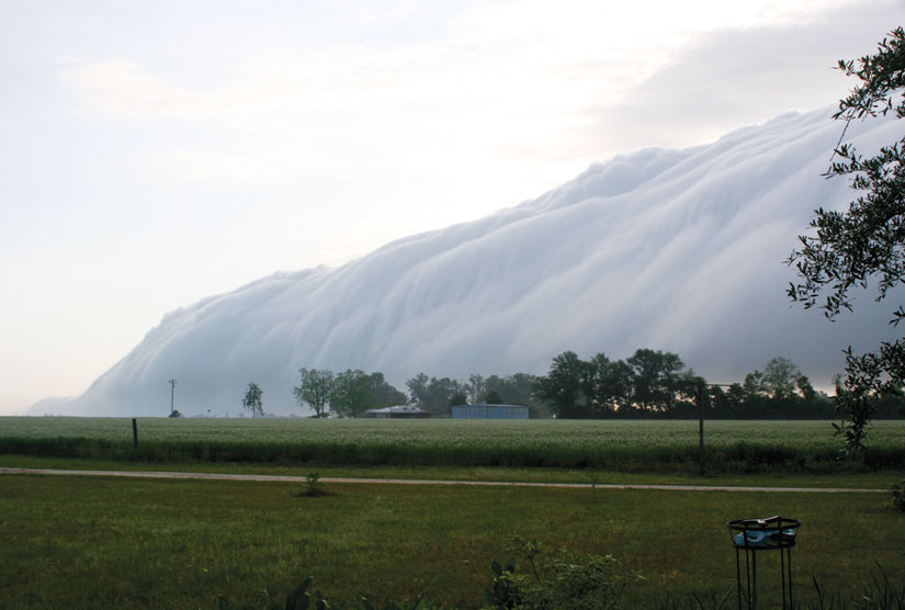
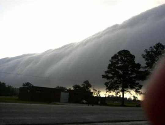
(Updated With New Photos) Amazing. That’s the word the National Weather Service office in Mobile used when they looked at the above photograph. This rare cloud formation moved across North Escambia and South Alabama about 7:00 Wednesday morning.
Forecasters at the NWS did not know exactly what to call the cloud formation, settling on calling it just an “arc cloud”. They say the cloud would have been formed by a rapid surge of warm moist air. Forecasters told NorthEscambia.com that they had never actually seen anything exactly like it before.
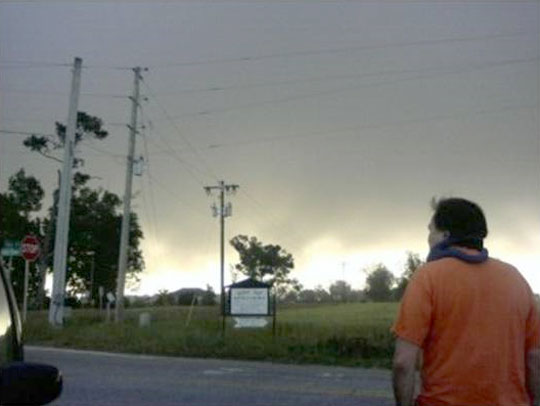
Reviewing high resolution visable satellite data, the weather service tells us that the cloud actually stretched from near Gulf Shores to Butler County, Alabama, for a brief period.
If you have photos of the rare cloud formation, email them to news@northescambia.com. Let us know where the photo was taken.
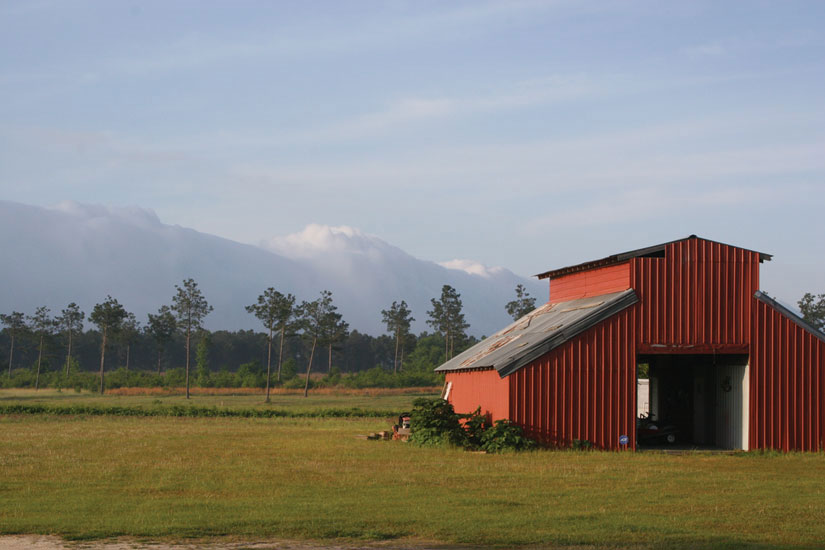
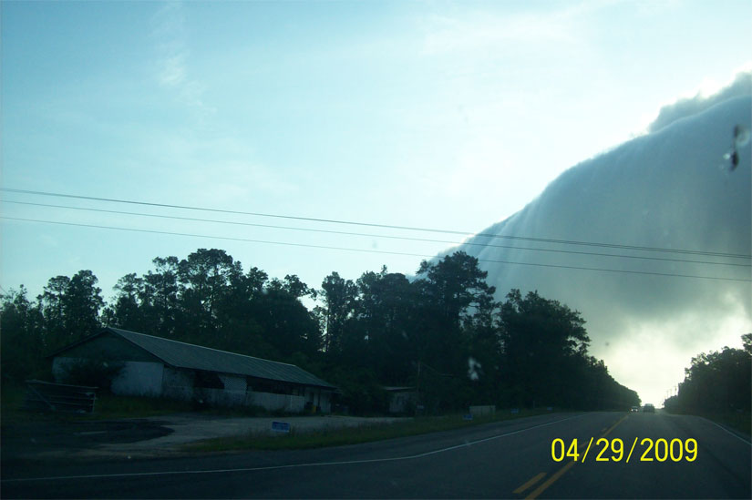
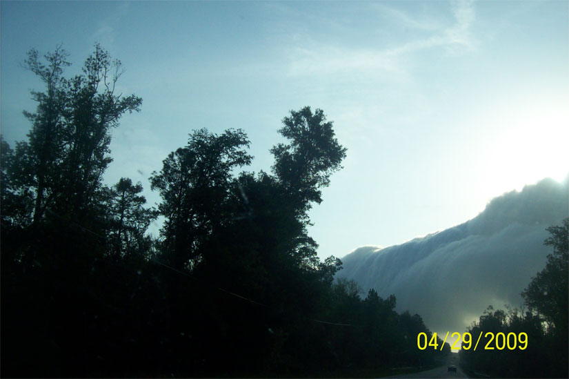
Pictured above: Walt Butler took this photo on Greenland Road in Davisville Wednesday morning. Pictured below, top: The cloud almost looks like a mountain behind the barn in this Walt Bulter photo also from Greenland Road. Pictured below: Two photos from Amy Akins of the clouds near Perdido, Ala. Pictured bottom in photos submitted by Marlene Rubi: The cloud rolls into Atmore and a photo as the cloud passes over Walnut Hill. Submitted photos for NorthEscambia.com, click to enlarge.
Comments
17 Responses to “Simply Amazing: Did You See It?”
It was truely amazing. I’m glad pics were posted, I was not able to take any.
Me and my daughter saw it too on the way to Bratt Elem. School. It was creepy and awsome at the same time. When my daughter got home from school that afternoon, she said that some of the teachers made a comment that the cloud could have been Jesus coming. I thought that was pretty cool.
I was driving my shool bus south on Schaag Road about 6:30 a.m. and we saw it! One of the Kids said ” is it going to get bad weather?” The clouds had a brown tint to it.and I noticed the wind was blowing. By the time we got to Hwy. 29, it was north of us.Then I started driving north on Hwy. 29 and it looked like high snow covered mountains in the north.It was something to see! This could be like the cloud that Jesus returns on!
I WISH I HAD MY CAMERA. IT WAS AMAZING>
i was waiting outside at the bus stop! my 6 yr old daughter seen it and said “oh my gosh”!!! which then brought it to my attention by the way she said it! it was very scary! like someone pulled a black blanket over the sun! but just as fast it went away! it was very scary standing there and watching it! at the same time i dont think i have ever or will ever see it again!!
I drove thru it and started singing” I’m headed to work”
Well, I’m a “J.S.” but not sure if I am the one EMD was telking to – but I think it had to have been mighty cool to see it – I saw something similar years ago, but I can’t say it was anything as awesome as that was.
Ditto Beegee. I know what you mean. I wanna know what J. S. thinks about all this.
I saw it,also!!!!! I started singing”I’m Going Home”!!!!!!!!
Boy,am I ever ready!!!!
My daughter and i was on our way to flomaton school when we came up on this. It was very neat and scary to. I thought this was it. Grabbed my daughters hand and prayed.
Those clouds are awsome, and creepy. I seen them while waiting for the bus, and it looked like a wall coming towards you. One moment I saw standing in the sun, adn the next it was all grey. I read WAY to many vampire, witch, werewolf, and demonic books for that to happen. Made me go on edge, if you know what I mean.
AMAZING!! Thanks for sharing the pictures!
From looking at the satellite images yesterday, this was likely a form of “gust front” accompanied by a very long “roll cloud”.
On Wednesday morning, inland areas were actually warmer than on the coast. Also, light fog was present, indicating high humidities. When water condenses into cloud droplets (fog), heat energy is released, raising temperatures. The earth is also releasing heat energy gathered from the sun the previous day.
Meanwhile to the south, the waters of the Gulf of Mexico still at temperatures in the high 60’s. This allows air over the Gulf surface to be cooled.
Cool air has greater density than warm air, therefore warm air will override cool air. (Note that commenter and observed “John” above states the temperature following the passage of the cloud dropped about 10 degrees F., or about 6 degrees C. This indicates the passage of a boundary of different air (both in temperature and water content, or humidity.)
Over the past week or so, there has been strong southeasterly winds coming from the tropics, across the peninsula of Florida, and streaming into our area. (Red flag warnings have been flying at the coast for days.) On Wednesday morning, a surge of this air came off of the coastal areas and into northwest Florida and south Alabama. This was clearly evident on visible satellite images. As the cool, dense air encountered the warmer air inland, the warm air overrode the relatively cool coastal air, forming what is known as a “roll cloud”. This cloud marked a boundary between warm and slightly cooler air, and it was impressive. The top of the roll cloud probably reached upward to around 2,000 to 3,000 feet above sea level. (By comparison, summer thunderstorms can reach the 55,000 to 60,000 foot level.) The roll clould was impressive because of its lenght. I measured it on a satellite image at about 130 miles in length.
Essentially, a gust front is like a miniature version of a cold front.
As the gust front and accompanying roll cloud continued north into Alabama and Mississippi, the rising air along the boundary triggered a few afternoon thunderstorms near Meridian, Mississippi.
LPM
Ditto to everything John said. I too was outside and watched this, it was very strange.
My daughter and I observed this on our drive to Bratt Elementary yesterday morning. We both thought it looked like a line of mountains across the sky. I wished then that I had my camera. I wished for that even more when as we sat in the car rider line at the school the entire line of clouds suddenly puffed up like marshmallows, rose up and totally obliterated the sun. The sky darkened, the wind started blowing and leaves were flying off the trees. My daughter actually got scared and asked me to roll up the car window. The cloud bank rolled over the top of us and as I looked back toward Atmore the sky looked like midnight. It was the most awesome thing I have ever seen and am glad to know we weren’t the only ones.
AWESOME!!! That almost makes me want to get up earlier and see what’s happening. I wonder if that has ever happened anywhere before…???????
Daughter and I watched it waiting for the school bus at 6:30 am cross Hwy 29 heading due west. I see none of the pictures here show how low the cloud formation was to the ground in reference to where we stood by Chestnut and Molino Rd. It created a heavy fog as it rolled past. Temperature dropped about 10 degrees as it rolled over us as did the wind. It looked to contain alot of dust as well. It appeared as if the cloud formation was drawn with a ruler…It was that straight. Inside this cloud it was roiling.The portion of the cloud was very very dark against the deep blue sky. No rain was involved. The whole event lasted only about ten to fifteen minutes. Everyone we saw just stared at it. Very eerie sight. Like something you see in a science fiction movie or watching Sand/Haboob storms in the Middle East and desert regions of the USA.
Hoped this has helped.