

Powder-Puff Football Tonight
April 8, 2010
Girls from Escambia Academy will take on girls from Escambia County High School this afternoon in a benefit Powder-Puff football game.
The event is a fundraiser for a Youth Leadership Atmore Class of 2010 service project to purchase books for Atmore area elementary schools. The game will take place at 5:30 p.m. at the Escambia County High School football stadium.
Admission is $3 at the gate. Concessions will be available.
Three Injured In Century Crash
April 7, 2010
Three people were injured in a two vehicle crash on North Century Boulevard at State Line Road this afternoon.
Reports indicated that a Toyota Prius and a Nissa Titus collided in the accident about 5:30 p.m. near the Piggly Wiggly. A 49-year old male, a 24-year old female and an infant were sustained non-life threatening injuries in the collision. The 8-month old was reportedly properly restrained in a car seat; the baby’s injuries were not immediately considered severe.
The accident is still under investigation by the Florida Highway Patrol. Atmore Ambulance, the Century Station of Escambia Fire Rescue and the Escambia County Sheriff’s Department also responded to the collision,.
Rain Forecast By Early Morning, Cooler Air Moving In
April 7, 2010
We are in for another warm, sunny day, but big changes are in store.
There is some rain in overnight and Thursday morning forecast. By the end of the week, our overnight lows will dip down to near 42.
Here is your official North Escambia area forecast:
- Tonight: Scattered showers and thunderstorms after 1am. Patchy fog after 1am. Otherwise, mostly cloudy, with a low around 65. South wind between 10 and 15 mph. Chance of precipitation is 50%.
- Thursday: Showers and thunderstorms likely, mainly before 1pm. Cloudy, with a high near 71. South wind around 10 mph becoming northwest. Chance of precipitation is 60%.
- Thursday Night: Isolated showers before 1am. Cloudy during the early evening, then clearing, with a low around 45. North wind between 5 and 10 mph. Chance of precipitation is 20%.
- Friday: Sunny, with a high near 72. North wind around 5 mph.
- Friday Night: Mostly clear, with a low around 43. Northeast wind around 5 mph.
- Saturday: Sunny, with a high near 75. East wind around 5 mph.
- Saturday Night: Mostly clear, with a low around 42. East wind around 5 mph becoming calm.
- Sunday: Sunny, with a high near 77. Calm wind becoming east between 5 and 10 mph.
- Sunday Night: Partly cloudy, with a low around 49.
- Monday: Mostly sunny, with a high near 76.
- Monday Night: Partly cloudy, with a low around 52.
- Tuesday: Mostly sunny, with a high near 77.
Dense Fog Advisory
April 6, 2010
The National Weather Service in Mobile has issued a dense fog advisory in effect until 9:00 this morning.
Area traffic cameras along with surface observations indicate dense fog has become widespread across portions of Mobile and Baldwin County along with many areas in the western Florida Panhandle. Visibilities will improve by mid morning.
Precautionary/preparedness actions…
A dense fog advisory means visibilities will frequently be reduced to less than one quarter mile. If driving, slow down, use your headlights, and leave plenty of distance ahead of you.
Lane Closures Continue Today On Highway 4 Bridge
April 6, 2010
Motorists can expect delays on Highway 4 between Escambia and Santa Rosa counties on Tuesday.
Florida Department of Transportation bridge inspectors will perform a routine inspection on the Escambia River Bridge on Highway 4. Motorists will encounter lane restrictions between 8 a.m. and 4 p.m. both days.
According to FDOT, drivers are reminded to use caution, watch for traffic flaggers, and to obey the posted speed limit when traveling through the work zone.
A Warm Sunny Monday, Rain Later This Week
April 5, 2010
After some morning fog, were are in for our warmest day so far this year under sunny skies. There is a chance of rain on Thursday, otherwise we have a dry week in store.
Here is your official North Escambia area forecast:
- Monday: Becoming mostly sunny, with a high near 85. South wind between 5 and 10 mph.
- Monday Night: Mostly clear, with a low around 55. South wind around 5 mph.
- Tuesday: Mostly sunny, with a high near 82. South wind between 5 and 15 mph.
- Tuesday Night: Partly cloudy, with a low around 58. South wind between 5 and 10 mph.
- Wednesday: Partly sunny, with a high near 82. South wind between 5 and 15 mph, with gusts as high as 20 mph.
- Wednesday Night: A 20 percent chance of showers and thunderstorms. Mostly cloudy, with a low around 60. South wind between 5 and 10 mph.
- Thursday: A 50 percent chance of showers and thunderstorms. Mostly cloudy, with a high near 75. Southeast wind 10 to 15 mph becoming west. Winds could gust as high as 25 mph.
- Thursday Night: Partly cloudy, with a low around 44. West wind between 10 and 15 mph, with gusts as high as 25 mph.
- Friday: Mostly sunny, with a high near 70.
- Friday Night: Partly cloudy, with a low around 45.
- Saturday: Mostly sunny, with a high near 77.
- Saturday Night: Partly cloudy, with a low around 48.
- Sunday: Mostly sunny, with a high near 78.
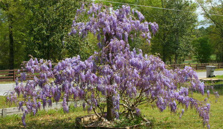
Pictured above: Lynda in Molino shares a photos of her wisteria with us. Do you have a photo you would like to share? Email news@northescambia.com. Submitted photo for NorthEscambia.com, click to enlarge.
Sunrise Services And More Planned Across Area
April 4, 2010
A variety of events are planned for Easter across the North Escambia area.
- Molino – Aldersgate United Methodist Church in Molino will hold the following events: Compline on Easter Sunday at 6:30 p.m.
- Bratt – The First Baptist Church of Bratt will present the Easter Cantata “I Will Rise” on Sunday, April 4 at 10:30 a.m.
- Molino – CrossFaith Church will begin Easter Morning at 10:00 with a youth drama “arise my love”. The young children will also do an Easter drama and then an Easter Egg Hunt outside. Wonderful praise and worship and awesome Word for the adults.
- Cantonment – St. Monica’s Episcopal Church at 695 South Highway 95A will hold the following events: Easter Sunday, 7 a.m., Sunrise Service, 10:30 a.m. Holy Eucharist followed by an Easter Egg Hunt.
- Atmore – The Atmore First United Methodist Church will present the Easter cantata “I Know My Redeemer Lives” on April 4 at 10:30 a.m.
- Atmore – The First Presbyterian Church of Atmore, 208 East Horner Street, will have an Easter Sunday worship services at 10:30 a.m.
- Walnut Hill – The Walnut Hill House of Prayer at 52 North Cypress Street will have an Easter Singing at Sunday, April 4 at 7:30 p.m. with special guest Bishop Willis Phillips.
- Walnut Hill – Walnut Hill Baptist Church will hold its annual Spring Jubilee at the church on April 10th beginning at noon. After eating lunch and children’s/youth games and egg hunt, everyone will go to Bradberry Park for a baseball game.
- Molino – The Easter musical “The Easter Pageant That Almost Wasn’t” will be presented at 6:30 p.m. on Sunday, April 11 at Aldersgate United Methodist Church in Molino.
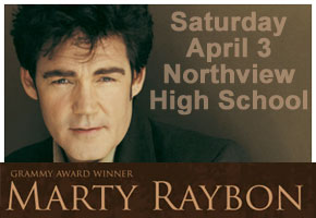
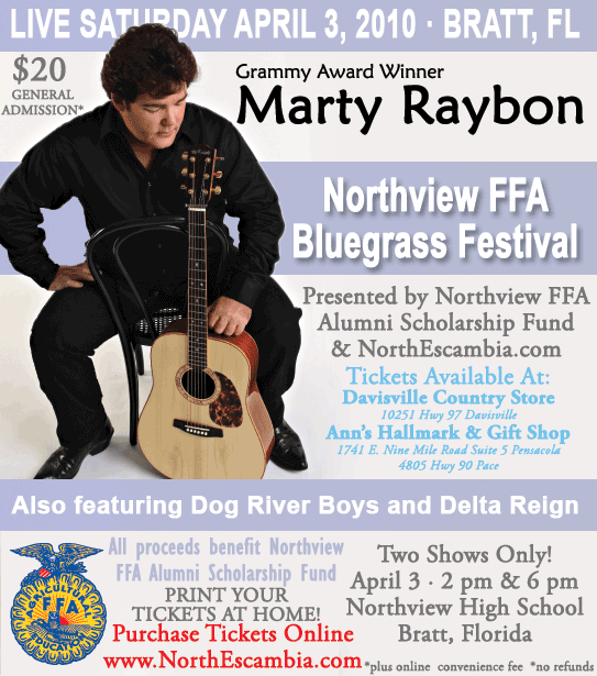
Northview FFA Alumni Bluegrass Festival With Marty Raybon Is Today
April 3, 2010
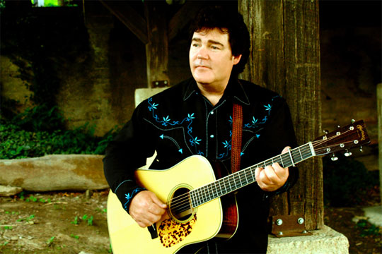
Today is the big day for the Northview FFA Bluegrass Festival featuring Marty Raybon presented by the Northview FFA Alumni Scholarship Fund and NorthEscambia.com. There is one show remaining today at 6 p.m. at the Northview High School Theater.
Tickets will be available at the door.
The Northview Band Boosters will be selling gumbo for $3 per bowl, hot dogs for $1, and chips and drinks for $1 before and during the concert to raise money for an upcoming trip to Orlando for a performance at the Music USA 2010 Festival. It is not necessary to attend the concert in order to purchase the concessions and support the band.
Several political candidates will have tables set up in the lobby before the concerts to meet and greet the public, including Doug Broxson, Dave Murzin, Walter B. Hill and Larry Walker.
Marty Raybon is a man that achieved legendary status in country music — 13 number one singles, 22 songs on the charts, a Grammy Award, and a CMA Vocal Group of the Year trophy.
Marty Raybon is perhaps best known as the former lead singer of the country mega-group Shenandoah from 1985-1996. . He led Shenandoah to 22 singles on the Billboard Hot Country Songs charts, including thirteen number one singles, such as: “The Church on Cumberland Road” (1989), “Sunday in the South” (1989), “Two Dozen Roses” (1989), “Next to You, Next to Me” (1990) and “Butterfly Kisses” (1997). At the top of the charts, Raybon became known for his bluegrass and gospel-influenced semi-traditional country sound.
 Raybon offers a full spectrum of vocal entertainment. His talents are unmatched, whether he’s singing country, gospel or his personal favorite, bluegrass. He has become one of country music’s busiest artists, performing over 100 shows per year between the United States and Canada.
He grew up in bluegrass and later earned acclaim in country music, so it should come as no surprise that the latest release from Marty Raybon and his band, Full Circle, bears the mark of both.
“I love bluegrass,” Raybon says with a passion, “and I love to see young people love it. I was younger than a lot of them are when I started playing, and I’d sit in school and try to draw Bill Monroe’s mandolin peghead. That’s how into it I was then–and I still am. When we go out there and see young people at our show, it makes us feel really good, and all we want to do, whether it’s at a show or on this album, is entertain them and let them feel good.”
All proceeds from the Northview FFA Bluegrass Festival will benefit the Northview FFA Alumni Scholarship Fund.
This is an indoor event at Northview High School, 4100 W. Highway 4, Bratt, Florida. For a map, click here.
Free Fishing Weekend In Florida
April 3, 2010
Both residents and nonresidents in Florida can fish in public fresh waters across the state without a license Saturday and Sunday. All other fishing rules apply.
The Florida Legislature and Florida Fish and Wildlife Conservation Commission (FWC) designated the first full weekend in April each year to be Florida’s Free Freshwater Fishing Weekend. This year, that falls on Easter weekend.
(Submitted by the Florida Fish and Wildlife Conservation Commission)
This is a great opportunity for experienced anglers to share their love of the sport with family and friends. It’s also a great opportunity to join the thousands of anglers who have taken the Anglers’ Legacy Pledge by visiting www.AnglersLegacy.org and entering partner code FLFWC. Anglers’ Legacy is about giving back what you’ve been given, and making a promise to introduce somebody new to fishing. There’s no membership fee and no obligation – it’s just another great way to help spread the fun of one of America’s most popular traditions and share our fishing heritage with others.
The Get Outdoors Florida! coalition (www.GetOutdoorsFlorida.org) encourages everyone, and especially children, to connect with nature by getting outdoors and enjoying active, nature-based recreation. Research conducted in 2009 by the Outdoor Foundation emphasized that recreational fishing is the number-one gateway activity that leads participants to increase their overall involvement in outdoor activities. This is vitally important as numerous diverse and extensive studies, such as those documented by Richard Louv in his best-selling book “Last Child in the Woods,” and expanded upon by the growing Children and Nature Network (www.ChildrenandNature.org), have demonstrated that activities such as fishing can lead to happier, healthier and smarter lifestyles.
So this weekend is your chance to get outdoors and go fishing right here in the “Fishing Capital of the World,” where virtually everyone is within 45 minutes of a freshwater fishing opportunity. No excuses! The weather predictions are looking good, it is just after a full moon and spring stimulates fish to congregate in shallow waters. The fishing should be great. So, Get Outdoors Florida! and burn off some of those chocolate-bunny calories with a free fishing adventure.
Visit MyFWC.com/Fishing to learn about fishing regulations in Florida.
Six Winners Receive Concert Tickets To Today’s Marty Raybon Show
April 3, 2010
Six lucky NorthEscambia.com readers won a pair of tickets each to Saturday’s Northview FFA Alumni Bluegrass Festival Featuring Marty Raybon.
The six winners were:
- Elizabeth Vinson, Atmore
- Tracy Baker, McDavid
- Amy Holland, Bratt
- Katie Simpson, Cantonment
- Karin Green, Cantonment
- Kelly Archer, Jay
Winners have received an email containing their concert tickets. If you are a winner and did not receive that email, contact us at news@northescambia.com from the email address you used to enter the contest.