

Stalled Front Means Rain
October 4, 2009
A front stalled over the Gulf Coast will bring the North Escambia area an increased chance of rain for the next couple of days.
Here is your complete North Escambia forecast:
- Today…Scattered showers in the morning…then widespread showers and scattered thunderstorms in the afternoon. Highs in the upper 70s. East winds 5 to 10 mph becoming southeast 10 to 15 mph in the afternoon. Chance of rain 90 percent.
- Tonight…Widespread showers and scattered thunderstorms. Near steady temperature in the lower 70s. Southeast winds 5 to 10 mph. Chance of rain near 100 percent.
- Monday…Cloudy. Numerous showers and scattered thunderstorms. Highs in the lower 80s. Southwest winds 5 to 10 mph. Chance of rain 70 percent.
- Monday Night…Cloudy. Scattered thunderstorms and isolated showers. Lows in the mid 60s. Southeast winds around 5 mph. Chance of rain 20 percent.
- Tuesday…Mostly cloudy. Scattered showers and thunderstorms. Highs in the lower 80s. South winds 5 to 10 mph. Chance of rain 50 percent.
- Tuesday Night…Cloudy. Numerous showers and thunderstorms. Near steady temperature in the mid 70s. Chance of rain 60 percent.
- Wednesday…Partly sunny. Scattered showers and isolated thunderstorms. Highs in the mid 80s. Chance of rain 50 percent.
- Wednesday Night…Mostly cloudy. Isolated showers and thunderstorms. Lows in the lower 70s. Chance of rain 20 percent.
- Thursday…Partly sunny. Chance of showers and thunderstorms. Highs in the upper 80s. Chance of rain 40 percent.
- Thursday Night…Mostly cloudy. Slight chance of showers and thunderstorms. Lows in the lower 70s. Chance of rain 20 percent.
- Friday…Partly sunny. Chance of showers and thunderstorms. Highs in the mid 80s. Chance of rain 40 percent.
- Friday Night…Mostly cloudy. Chance of showers and thunderstorms. Lows in the upper 60s. Chance of rain 40 percent.
- Saturday…Not as warm. Cloudy. Chance of showers and thunderstorms. Highs in the mid 70s. Chance of rain 40 percent.
Jay Peanut Festival Will Attract Thousands
October 3, 2009
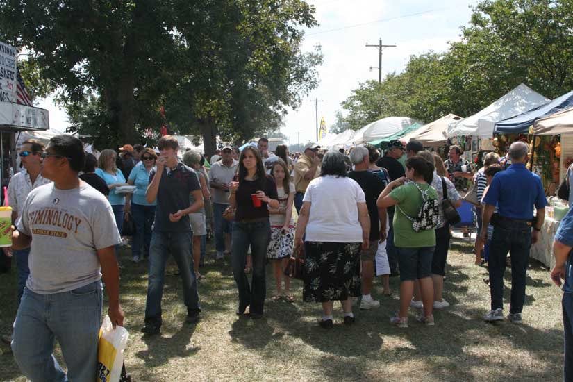
The 20th Annual Jay Peanut Festival is expected to attract about 70,000 people this weekend.
The Peanut Festival will feature something fun for everyone including arts and crafts, antiques, inflatable rides, rock climbing wall, pony rides, hay rides, train rides and much more. The Gabbert’s 1930’s Farm Museum will also be open for tours. There will be plenty of food available…kettle corn, BBQ, hamburgers, roasted corn, apple dumplings and more.
And, of course, peanuts will be the star of the festival, and there will be plenty of green peanuts and boiled peanuts as well as fried, roasted and candied peanuts.
Admission and parking are free, but the Jay High School FFA will be hosting the first annual Keith Rowland Memorial Scholarship fundraiser during the Peanut Festival. You can support the Jay FFA by parking your car on the designated grounds at the Rowland home. (3696 Pine Level Chruch Road) A trolley cart will be provided for transport. We are asking for a $4.00 donation. All proceeds will go to the Keith Rowland FFA Memorial Scholarship Fund.
The event is dedicated to the memory of Melissa Caroline Gabbert, who died of cancer in 1990. The Jay Peanut festival will take place until 6 p.m. Saturday and from 9 a.m. to 6 p.m. on Sunday at Gabbert Farm south of Jay off Highway 89 at 3604 Pine Level Church Road. (A map is at the bottom of this page.)
Pictured above: Large crowds attended the annual Jay Peanut Festival last year. NorthEscambia.com file photos, click to enlarge.
Reunion Today For 1985-1995 Ernest Ward Graduates
October 3, 2009
Ernest Ward High School alumni who graduated from 1985 to 1995 will have the chance to see old friends at a combined class reunion today.
Graduates are invited to family-friendly lunch at the Walnut Hill Community Center from 11 a.m. to 3 p.m. Attendees are asked to bring lunch and drinks for their family.
Saturday evening there will be an adults-only event at McGuire’s Irish Pub in Pensacola from 7 p.m. until. There is a charge of $20 per person for the evening event, which will cover non-alcoholic drinks and hors d’oeuvres.
Organizers want to stress this combined class reunion event is not taking the place of the Class of 1989 reunion. The Ernest Ward High School Class of 1989 will hold a reunion from 7 to 11 p.m. October 10 at the Wind Creek ballroom in Atmore. Contact Cindy Darby Lee at (251) 446-8192 or email gosport1@frontiernet.net.
Northview Homecoming: All You Need To Know
October 2, 2009
It will be a big day in Bratt with the 2009 Homecoming at Northview High School
The day’s events will begin with a homecoming parade at 12:30 from Bratt Elementary to Northview. Click here for complete parade information.
The Northview Homecoming Court will be presented at 6 p.m., followed the crowning of the NHS Homecoming Queen.
The game against Baker will kick off at 7:00 p.m.
During the game, all Northview High School alumni from 1996-2009 are invited to visit an alumni tent located in the stadium.
After the game, the NHS cheerleaders are sponsoring a homecoming dance until 12:30 a.m.
Then on Saturday, NorthEscambia.com will have complete coverage — including hundreds of photos — from the parade, homecoming court and the game.
Ernest Ward Students Checked Out For Parade Will Be Excused
October 2, 2009
All students checked out from Ernest Ward Middle School for today’s Northview Homecoming Parade will be excused.
Principal Nancy Gindl-Perry said students should be checked out after 11:30 if at all possible. They will not be required to return to school, and they will be excused, she said. Teachers should not be giving any tests or graded assignments, and, if they do, students will have the opportunity to make them up on Monday.
A photo identification is necessary to check a student out at Ernest Ward, and the parent or guardian must be listed as authorized to checkout the student with the school.
Over 350 To Participate In Northview’s First Homecoming Parade Today
October 2, 2009
The first Northview High School Homecoming Parade at 12:30 afternoon in Bratt will feature about 35 units and over 300 students on a route from Bratt Elementary School to Northview.
The parade will be led by Escambia County Sheriff David Morgan and Escambia County Commissioner Kevin White, followed by the Northview High School Tribal Beat band.
There are floats scheduled to be in the parade from the seniors, juniors, sophomores, freshmen, art class, volleyball team, NHS alumuni and the “Senior II” float. The Northview Varsity and Junior Varsity footballs teams will be in the parade, along with cheerleaders from Northview and Ernest Ward Middle School. Mascot Raylin Spence will be riding in the parade.
Century Mayor Freddie McCall and Carl Ward will be in their vintage cars, and Bratt’s unofficial mayor, Donnie Bass, will also make an appearance.
Fire trucks from Walnut Hill, Century, McDavid, Molino and Poarch will also be in the parade. The Northview NJROTC platoon, NJROTC Color Guard, DCT, FBLA, FFA and SGA will also take part.
WEAR-TV 3 personality Mollye Barrows is scheduled to ride in the parade in the station’s satellite truck.
An estimated 275 Northview students will take part in today’s parade.
Spectators are encouraged to arrive early to claim the best spots along Highway 4.
NorthEscambia.com will be there along the parade route, and we will have a complete photo gallery post Saturday morning.
Barrineau Park Music Night Tonight
October 2, 2009
There’s some good entertainment on stage tonight in Barrineau Park — and it’s free.
The monthly Barrineau Park Music Night will be tonight at the Barrineau Park Community Center. The featured groups tonight are “Southern Sounds” and “Harold & Ovaline”.
The singing starts at 7 p.m. and is free. Food and refreshments will also be available beginning at 6 p.m.
The event is family-friendly — no alcohol is permitted on the property, and no smoking is allowed in or near the building.
For more information, call (850) 587-5575.
The Barrineau Park Community Center is located on Barrineau Park School road, about three miles west of Molino.
Want To Learn More About Law Enforcement?
October 1, 2009
The Escambia County Sheriff’s Office is currently taking applications for a Citizens Law Enforcement Academy class.
Classes will be held beginning Thursday, September 17 and will cover information about various ECSO units including patrol, narcotics, K-9, crime scene, investigations and more.
The classes will be held from 5 to 8 p.m. on Thursdays at the ECSO main administration building, providing an opportunity to gain an in depth understanding of the challenges faced by law enforcement.
Participants will also learn about the training, techniques and technology used to fight crime and keep the community safe. Food and drinks are provided to participants. There is no charge for the academy but seating is limited.
Applications and more information are available from the front desk in the Sheriff’s Department main administration building at 1700 West Leonard Street by calling the Community Oriented Policing Office at (850) 436-9281.
Final Day For Business Owners To Renew Tax Receipt License
September 30, 2009
If you have a business and have not renewed your business tax receipt yet, now is the time.
The final day for all business owners and practicing professionals to renew their business tax receipt (sometimes called a business license) is Wednesday. After today, penalties will be added to the base fee.
Business owners and professionals are encouraged to renew their business tax receipt online; however, other options are available, such as payment by mail, by phone (convenience fee may apply), and in person at any of the four convenient tax collector offices.
Applications and information for business tax receipts are available at www.escambiataxcollector.com. If you have any questions or would like to make an appointment, please call the tax collector’s office at 438‑6500, Ext. 252. (TTY users for the hearing impaired call 472‑0031.)
Better Late Than Never: Ernest Ward Students To Receive Progress Reports Today
September 29, 2009
Students at Ernest Ward Middle School will receive their progress reports today — almost a week late.
The first nine-weeks progress reports were scheduled to be sent home with students last Wednesday afternoon, but many students in the county, including those at Ernest Ward, did not receive their report due to a software problem with the school district’s grading system.
If you have any questions, contact your child’s school.